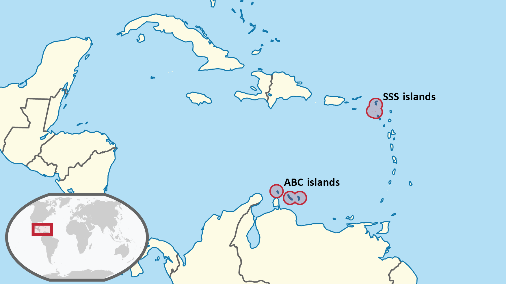
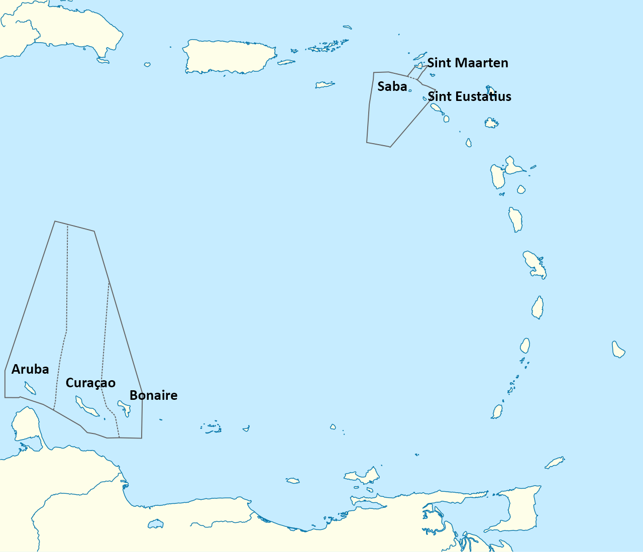
Geography of the Dutch Caribbean
The Dutch Caribbean Species Register covers the biodiversity of the major and minor islands in the Caribbean that are part of the Kingdom of the Netherlands. These islands comprise Aruba, Bonaire, Klein Bonaire, Curaçao, Klein Curaçao – commonly known as the ABC islands – as well as Saba, Sint Eustatius, and Sint Maarten – commonly known as the SSS islands . It also includes all bordering named and unnamed islets (e.g. Green Island). The ABC islands are located off the coast of Venezuela in the southern Caribbean, the SSS islands are located in the northeastern part of the Caribbean, part of the Lesser Antilles islands chain.
Besides the terrestrial areas of these six major islands, the following marine areas are included: the Exclusive Economic Zones and the Saba Bank.
We use the following definitions of geographical areas throughout this database in line with the publication on endemic species of Saba, Sint Eustatius and Sint Maarten of 2018 (Bos et al. 2018). However, we also try to be as precise as possible, so if a species is (only) reported from the French part Saint-Martin, it is presented for Sint Maarten with code 3c (to be expected). This goes for terrestrial as well as marine species.
West Indies: Greater Antilles, Lesser Antilles (in the broadest sense), Lucayan Archipelago (Bahamas, Turks and Caicos Islands). This sometimes includes coastal areas of Belize, Colombia, Venezuela, and the Guianas.
Caribbean: Greater Antilles and Lesser Antilles, sometimes including Lucayan Archipelago.
Antilles: Greater Antilles and Lesser Antilles (Caribbean in its narrowest definition)
Greater Antilles: Grouping of the larger islands in the Caribbean: Cuba, Hispaniola (containing Haiti and the Dominican Republic), Puerto Rico, Jamaica, and the Cayman Islands
Lesser Antilles sensu lato (s.l.): Leeward Islands and Windward Islands (Lesser Antilles in the strict sense), plus Trinidad and Tobago, Leeward Antilles (Lesser Antilles in the broad sense).
Lesser Antilles sensu stricto (s.s.): Leeward Islands and Windward Islands only. Axelrod’s vademecum of plants on Statia uses this definition, but excludes The Virgin Islands.
Lesser Antilles: Northern and Southern Lesser Antilles.
Northern Lesser Antilles: All islands from the Virgin Islands, southwards up to and including Montserrat.
Southern Lesser Antilles: All islands after Montserrat up to Tobago.
Leeward Islands: Most northern island chain of the Lesser Antilles: Virgin Islands, Anguilla, Sint Maarten (Saint Martin), Saint Barthélemy, Saba, Sint Eustatius, Saint Kitts, Nevis, Barbuda, Antigua, Redonda, Montserrat, Guadeloupe, La Désirade, Îles des Saintes, Marie-Galante.
Windward Islands: Southern island chain of the Lesser Antilles: Dominica, Martinique, Saint Lucia, Saint Vincent and the Grenadines, Grenada.
Leeward Antilles: Southwestern island chain of the Lesser Antilles, sometimes also referred to as southern Caribbean Islands: Aruba, Bonaire, Klein-Bonaire, Curaçao, Klein-Curaçao, and the Venezuelean islands Los Monjes Archipelago, La Tortuga, La Sola, Los Testigos, Los Frailes, Patos, Los Roques Archipelago, La Blanquilla, Los Hermanos, La Orchilla, Las Aves Archipelago, Isla Margarita, Coche, Cubagua.
Anguilla Bank: Anguilla, Sint Maarten, St. Barthélemy.
St. Kitts Bank: Sint Eustatius, St. Kitts, Nevis.
Dutch Caribbean: Aruba, Bonaire, Klein-Bonaire, Curaçao, Klein-Curaçao (part of the Leeward Antilles) and Saba, Sint Eustatius and Sint Maarten (part of the Leeward Islands).
Caribbean Netherlands: Bonaire, Klein-Bonaire, Saba, Sint Eustatius, also called the BES islands. They are special municipalities of The Netherlands.
ABC islands: Aruba, Bonaire, Klein-Bonaire, Curaçao, Klein-Curaçao (part of the Leeward Antilles).
SSS islands and surrounding islands: Saba, Sint Eustatius and Sint Maarten (part of the Leeward islands) and surrounding islands of Anguilla, St. Barthélemy, St. Kitts and Nevis.
SSS islands: Saba, Sint Eustatius and Sint Maarten (part of the Leeward Islands).
Saba Bank: A submarine atoll to the south-west of Saba and part of the Caribbean Netherlands. About one third of the Saba Bank lies within Saba’s territorial waters.